 FUJIFILM TIARA FUjinon 28mm F3.5, FUJI SUPERIA 400 |
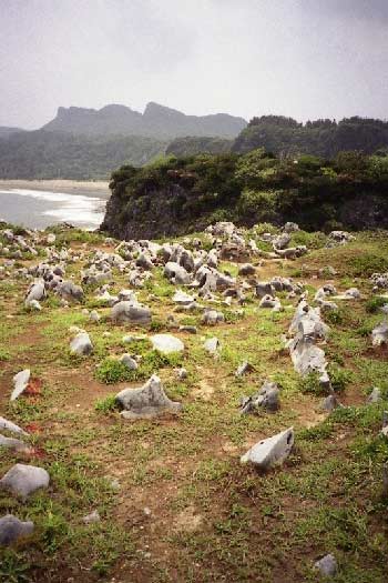
沖縄県国頭村 Kunigami Village, Okinawa Pref. 辺戸岬は沖縄島最北端に位置する。石灰岩が溶食され残ったカレンが見られる(手前の白い岩石)。この付近が海成段丘上であることは,海岸線からわかると思う。遠景の山は塔カルストの辺戸岳(別名辺戸御嶽,標高248.3m)で,中国の桂林と同じ成因である。 Cape Hedo is northern end of Okinawa Island. There are a lot of karrens which have developed as a result of the solution of rock by running or standing water. You will be able to understand that this location is on the coastal terrace. The far mountain, Mt. Hedo(another name is Hedo Utaki, 248.3m) is a tower karst as same as Guilin, China. <文献/Reference> A. Goudie ed. 1994. The encyclopedic dictionary of Physical Geography: second edition. Oxford, Basil Blackwell, 611p. 目崎茂和 1988. 『南島の地形:沖縄の風景を読む』沖縄出版,158p. 太田陽子・河名俊男・大村明雄 2001. 琉球外弧. 町田 洋ほか編『日本の地形7 九州・南西諸島』(東京大学出版会)所収,pp.232-271. |